AN INTRODUCTION
The Davyhurst Project is located approximately 120 km north west of Kalgoorlie, within the Tier 1 gold mining province of the eastern goldfields in Western Australia.
Ora Banda Mining’s (OBM) tenement package consists of 92 granted tenements covering an area of approximately 1,200 km2. This provides almost continuous coverage of approximately 130 strike kilometres of greenstone sequences prospective for gold as well as nickel sulphide and base metal mineralisation.
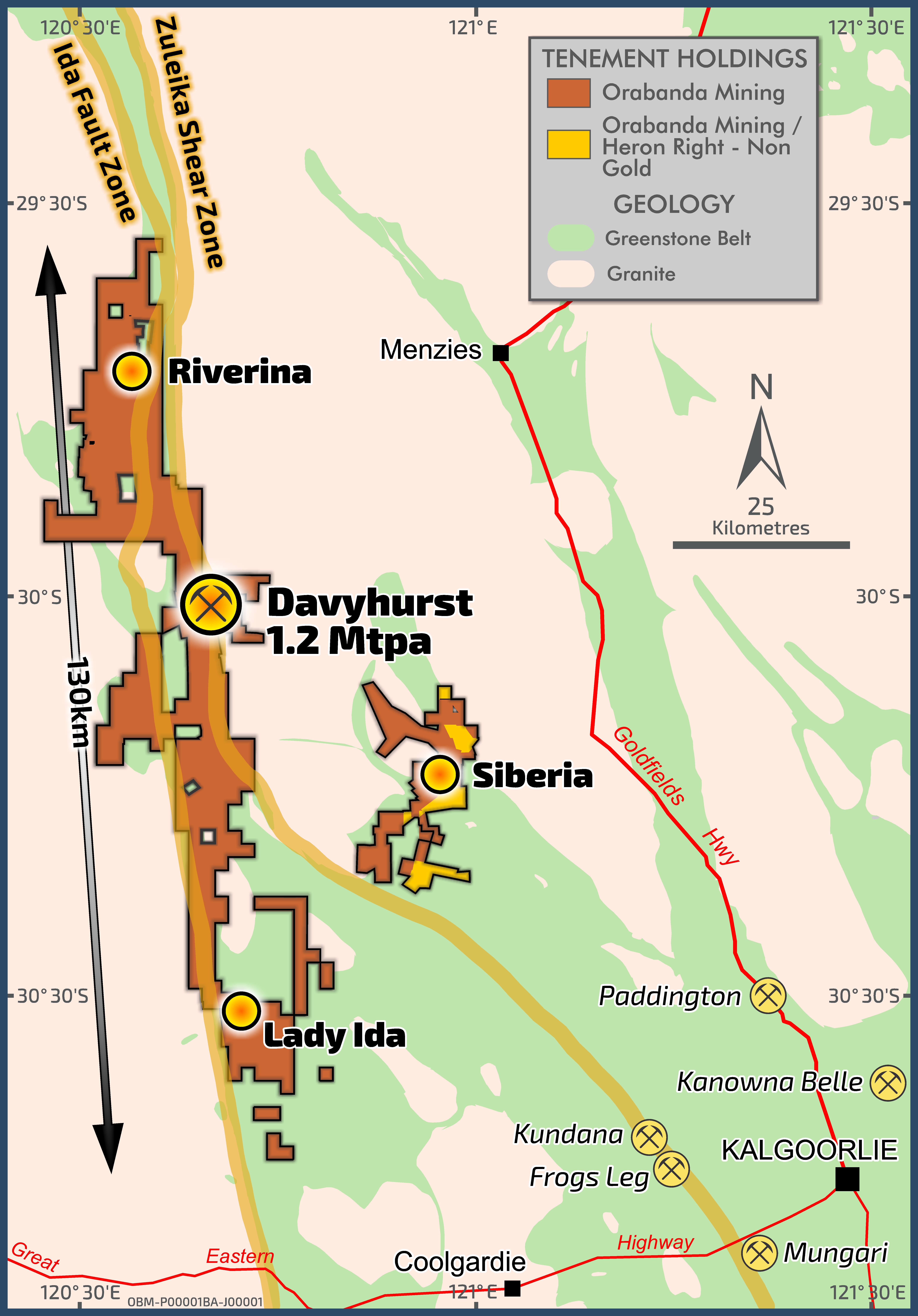
OBM Tenure & Simplified Geology
Ora Banda Mining is focused on unlocking significant value from our strategic and prospective landholding. To achieve this, the Company has targeted resource development activities at five advanced project areas: Riverina, Waihi, Siberia (Sand King and Missouri Deposits), Callion and Golden Eagle. This work cumulated in the delivery of a Definitive Feasibility Study (DFS), announced to the market on 30 June 2020.
The DFS confirmed development of the Davyhurst Project to be financially robust. Key outcomes include:
- Initial ~5.2-year mine life with first gold poured in Q1 CY2021
- 81koz per annum – average annual gold production
- A$68.8M – average annual free cash flow (at A$2,550/oz gold price)
The Davyhurst Project has significant pre-existing infrastructure in place including a 1.2 Mtpa conventional CIP processing facility, an extensive road network, 172-person camp, administration & workshop buildings and a large water bore field. This enabled a rapid, low capital pathway to production.
PROJECT LOCATION
The Davyhurst Project is centred on the historical Davyhurst townsite, which is located 120 km north west of Kalgoorlie. The tenement package is accessed from Kalgoorlie via Goldfields Highway and a series of well-formed, unsealed shire roads. Access to project areas on the tenure is provided by unsealed shire roads and haul roads. Airstrips are located at Davyhurst (Callion) and Riverina.
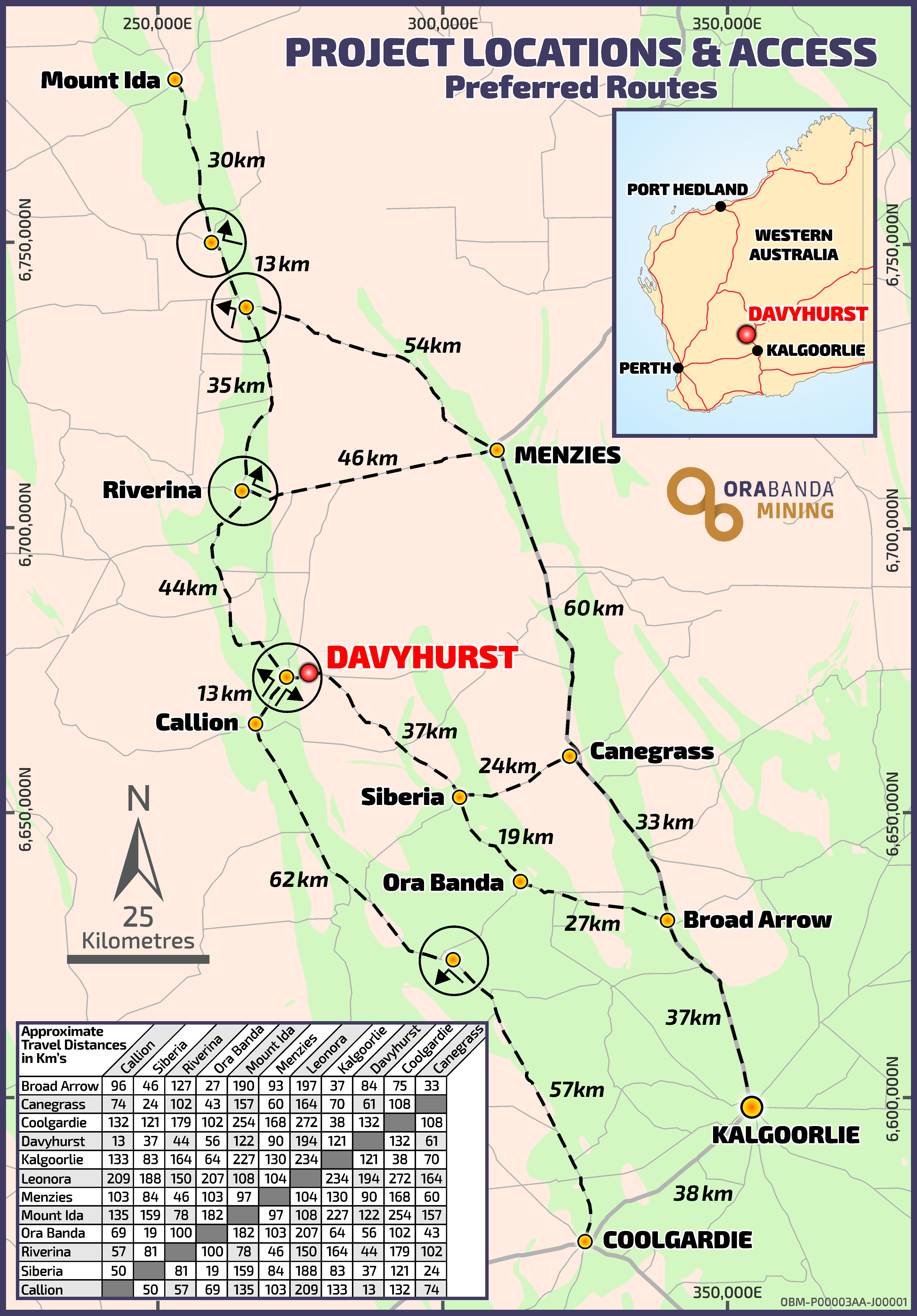
Project Location & Access
PROJECT HISTORY
Gold was discovered in the district in the 1890s by prospectors following greenstone belts northward from Coolgardie. Within the project area, mining towns were established at Callion, Davyhurst, Siberia, Ularring, Mulline, Copperfield and Mt Ida. Between 1890 and 1950, numerous small to medium scale underground mining operations were established within the project area with cumulative production of approximately 600,000 ounces of gold.
Modern exploration and mining in the district commenced in the mid-1980s. Since that time, numerous companies have conducted exploration or had production operations in a fragmented tenure environment covered by the current project area.
Consolidation of the disparate tenement holding was undertaken by OBM’s predecessor Monarch Gold Mining Ltd between 2002 and 2006. There has been no large-scale, coherent exploration undertaken on the project since this strategic tenement consolidation. The company has a unique opportunity to define the critical mass of resource and reserves across a large and under-explored tenure needed to create a long-term sustainable mining operation.
REGIONAL GEOLOGY
The Davyhurst Project is located on a western branch of the Norseman Wiluna Greenstone Belt. The Project straddles the boundary between the Kalgoorlie Terrane of the Eastern Goldfields Province and the Barlee Domain of the Southern Cross Province, which is defined by the crustal-scale Ida Lineament. The Project also includes portions of the Zuleika Shear which separates the Coolgardie and Ora Banda Domains within the Kalgoorlie Terrane.
The Barlee Domain, to the west of the Ida Lineament, comprises a sequence of banded iron formation (BIF), shale, chert, and basalt, all poorly outcropping against basement granites.
The Ida Lineament is a poorly defined structure, but is commonly interpreted to be along the western contact of the western most ultramafic unit as defined by aeromagnetic data. East of the Ida Lineament, greenstones of the Coolgardie and Ora Banda Domains consist of sedimentary and felsic volcanoclastic rocks to the west, and mafic to ultramafic volcanic rocks with lesser volumes of felsic rocks to the east. The Project is generally bounded by basement granite and gneiss terranes. Internal to the greenstone belt there are several granite intrusions of various ages. The most prominent of these granites is the Ularring Granite, located midway between the Davyhurst and Riverina area.
RESOURCES & RESERVES
Gold mineralisation is the principal target and occurs across all geological domains within the Project.
Bedrock gold mineralisation within the Project is structurally controlled and is generally associated with mafic and high-Mg volcanic and intrusive rocks.
Two principal deposit types are present:
– Brittle fracture quartz veining with associated biotite alteration and sulphide mineralisation.
– Lode style silica-biotite-pyrite altered shear zones with minor quartz veining.
The Project has a mineral resource inventory of 1.95Moz @ 2.6g/t. The Company has defined mineral reserves inventory of 190koz @ 2.7g/t.
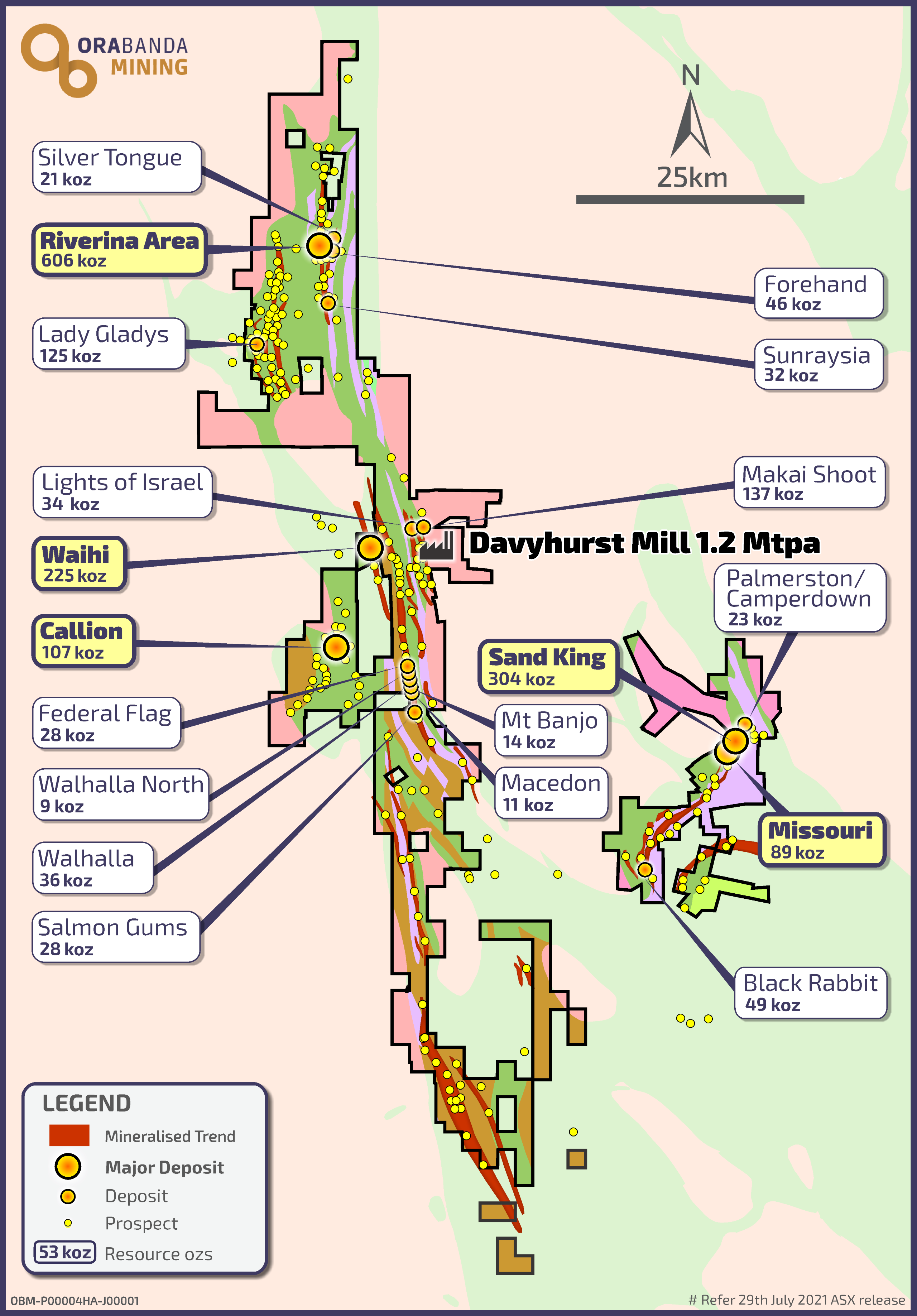
OBM Resources
MINERAL RESOURCES
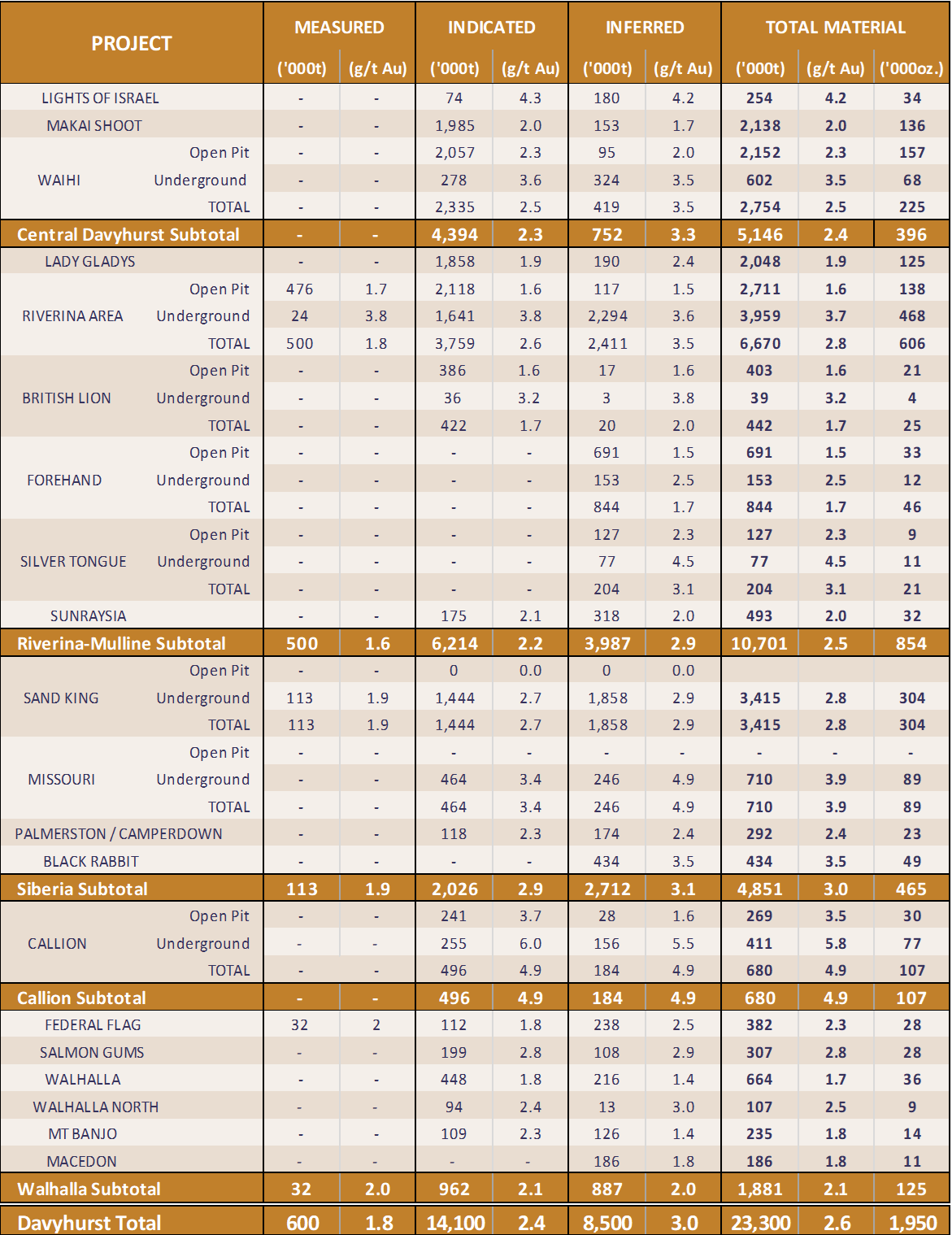
OBM - Global Mineral Resources
- The Riverina Area, British Lion, Callion, Forehand and Silver Tongue Mineral Resources have been updated in accordance with all relevant aspects of the JORC code 2012, and initially released to the market on 2 December 2019, 26 May 2020, 5 June 2020, 9 October 2020, 1 August 2022 & 16 February 2023 (Riverina Area), 15 May 2020 & 29 June 2020 (Callion), 29 July 2021 (Forehand, Silver Tongue & British Lion)
- The Sand King, Missouri and Waihi Mineral Resources have previously been updated in accordance with all relevant aspects of the JORC code 2012, and initially released to the market on 3 January 2017 & 26 May 2020 (Sand King), 15 December 2016 & 26 May 2020 (Missouri), 4 February 2020 (Waihi). Further updates to Sand King and Riverina are provided in this release.
- All Mineral Resources listed above, with the exception of the Missouri, Sand King, Riverina Area, British Lion, Waihi, Callion, Forehand and Silver Tongue were prepared previously and first disclosed under the JORC Code 2004 (refer Swan Gold Mining Limited Prospectus released to the market on 13 February 2013). These Mineral Resources have not been updated in accordance with JORC Code 2012 on the basis that the information has not materially changed since it last reported.
- The Riverina, British Lion, Waihi, Callion, Forehand and Silver Tongue Open Pit Mineral Resource Estimates are reported within a A$2,400/oz pit shell above 0.5g/t. The British Lion, Waihi, Missouri, Callion, Forehand and Silver Tongue Underground Mineral Resource Estimates are reported from material outside a A$2,400 pit shell and above 2.0 g/t. Riverina Underground Mineral Resource Estimates are reported from fresh material below the A$2,400/oz pit shell within Mine stope optimised solids of dimensions 10m x 10m x 1.6m minimum width at a diluted cut-off grade of 1.3g/t. Sand King Underground Mineral Resource Estimates are reported from fresh material below 350mRL (base of open pit) within Mine stope optimised solids of dimensions 10m x 10m x 1.6m minimum width at a diluted cut-off grade of 0.8g/t.
- Resources are inclusive of in-situ ore reserves and are exclusive of surface stockpiles
- The values in the above table have been rounded.
MINERAL RESERVES
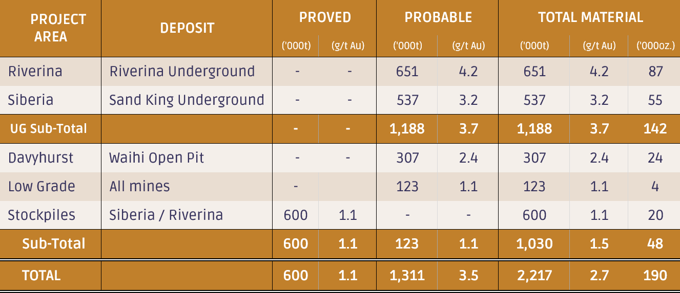
OBM - Global Mineral Reserves
- The table contains rounding adjustments to reflect accuracy and may not total exactly.
- This Ore Reserve was estimated from practical mining envelopes and the application of modifying factors for mining dilution and ore loss.
- For the open pit Ore Reserve, dilution skins were applied to the undiluted Mineral Resource estimate. The method also included internal and edge dilution resulting from forming practical mineable shapes. Dilution was incorporated in the model at the background grades estimated into the model: The average grade of dilution for Waihi was 0.16g/t. The estimated average dilution at Waihi was estimated to be 27%. Ore loss was incurred in the Auto Stope Designer (ASD) Deswik process due to variation between mineralised lode geometry and practical dig block geometry. In addition, a nominal 5% loss was applied for further mining losses occurring through normal operations.
- For the underground Ore Reserve, dilution skins were applied to the Mineral Resource estimate. Dilution was included at the background grade estimated into each model. The Riverina dilution is estimated to average 59% while Sand King is estimated to average 29%, reflecting mining shapes and orebody widths appropriate for each deposit.
- The Inferred Mineral Resource within the mining envelope was considered as waste when defining limits of these envelopes; however, minor amount of inferred material was included within the Riverina Underground and Sand King Underground mine plan due to practical mining geometries and orebody characteristics.
- The Waihi open pit Ore Reserve was primarily estimated using a cut-off grade of 1.2 g/t based on a gold price of A$2,600/oz. Low Grade reserve was based on A$3,000/oz. Costs used in the cut-off grade calculation allow for ore transport, processing, site overheads and selling costs as well as a historical global process recovery of 92%.
- The Ore Reserve is inclusive of surface stockpiles above cut-off. All surface stockpiles were classified as Proved.
- All low grade material is in situ.
- The Underground Ore Reserve was estimated using a cut-off grade of 2.5 g/t Au based on a gold price of A$2,250/oz, stopes were further spatially optimised. Costs used in the cut-off grade calculation allow for ore transport, processing, site overheads and selling costs as well as process recovery specific to the location. Process recoveries range for the project were estimated to be 87% or above, based on recent metallurgical test work.
- Inferred material within total Underground Ore Reserve equates to 24,250t at a grade of 4.5g/t. This material is included at the edges of the mining envelope and equate to 2.5% of the Ore Reserve inventories.
- Costs were derived from the FY25 budget estimate including underground contract pricing current at the date of this Ore Reserve and budget level contract pricing for Waihi. Unit costs for haulage, processing and site overheads were estimated based on scheduled process plant throughput of material above the economic cut-off grade. Full utilisation of process capacity is reliant on realising expected conversion of further Mineral Resource to Ore Reserve.